100-Mile Wilderness Project

Giving a recovering Maine forest room to regrow within the 100-Mile Wilderness.
The 100-Mile Wilderness Project is an Improved Forest Management (IFM) initiative spanning 13,000 acres of northern hardwood and spruce-fir forestland in Piscataquis County in northern Maine. The forest is recovering from decades of intensive timber management, including overstory removal and clearcutting under a previous industrial owner. Anew initiated the carbon project in 2020 with the then-landowner, the Elliotsville Foundation, and the Appalachian Mountain Club (AMC) purchased the property in 2023, adding it to its Maine Woods Initiative.
The project's baseline reflects the heavy cutting common on private forestland across the region, often through clearcutting and high grading. Instead, the project began with a 10-year zero commercial logging commitment, and revenue from carbon credit sales allows the forest to remain financially solvent while it recovers. The project generates both conservation and removal credits, registered under the American Carbon Registry.
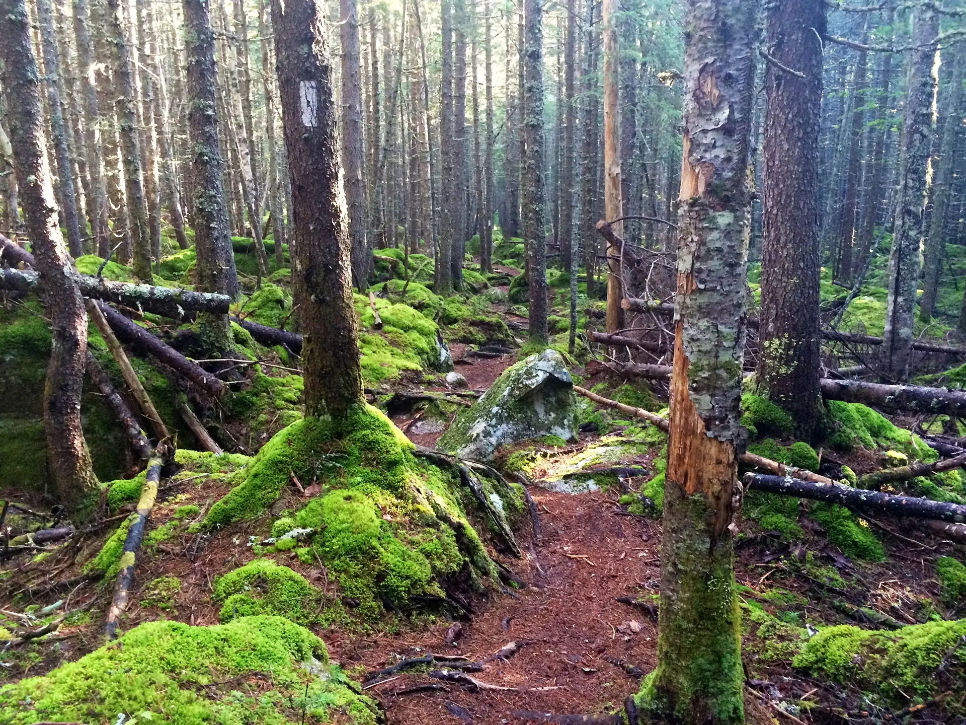
Beyond carbon impact, the property contains rivers that serve as habitat for the endangered Atlantic salmon, including the West Branch of the Pleasant River, Roaring Brook, and Houston Brook, along with habitat for Canada lynx, moose, and white-tailed deer. AMC is also reopening long-discontinued roads to restore local access to hunting and fishing areas, and leads environmental education in Piscataquis County public schools.

Additionality
The 100-Mile Wilderness Project includes 13,000 acres of northern hardwood and spruce-fir forestland in Piscataquis County in northern Maine. The property presents a variety of terrain from gentle and rolling to steep and jagged and is intersected with small streams and forested wetlands. It provides habitat for white-tailed deer, federally threatened Canada lynx, moose and American marten. The project property is now owned by the Appalachian Mountain Club (AMC). AMC purchased the property in 2023 after a forest carbon project had been initiated in 2020 by Anew and the previous landowner, the Elliotsville Foundation, marking a new era in carbon-led conservation for this land.
The forests across this project are recovering following decades of intensive timber management and the revenue from carbon credit sales allows this forestland to be financially solvent while it recovers. The Elliotsville Foundation, previously Elliotsville Plantation, Inc (EPI), purchased the property from an industrial timber manager who had harvested heavily using overstory removal and clearcutting. The property had a long history of contracting to logging companies even under EPI’s ownership. EPI’s investment goal was to promote the growth of high value hardwoods for long term commercial sawtimber management as well as to manage the forest for wildlife habitat and high-quality recreation. Prior to this forest carbon project, EPI intended to implement clearcuts to create early successional habitat and extended shelterwood selection. Instead, at the project’s initiation with Anew, they reduced harvesting through a 10-year zero commercial logging commitment. This tract is one of the last large land tracts remaining at the southern end of the North Maine Woods and its location at the edge of the region means it was susceptible to parcellation for residential development and small homesteads before AMC acquired it.
The Forest is now part of AMC’s Maine Woods Initiative, which has conserved over 113,000 contiguous acres within the 100 Mile Wilderness of Maine. AMC forestry is focused on growing old, diverse forests, using “natural dynamics” silviculture, with harvests designed to enhance the forest’s ecological resilience and economic productivity.
Looking south across the valley you’d see from the Appalachian Trail, from the peaks of these mountains, 20 years ago, you would have seen a pretty barren property, a property that had just been cut over. Even now, hikers from the Appalachian Trail looking over this landscape see a 14,000-acre property with much shorter trees than some of the neighboring properties. This carbon project will restore that view. As folks look out from the Appalachian Mountains, those hikers are going to see an intact place with much taller and older trees directly because of this carbon project.
— Steven Tatko, Vice President of Land Research and Trails, Appalachian Mountain Club
Baseline Description
The baseline scenario represents a harvest regime appropriate for the region and ownership type, subject to operational considerations in the region. Throughout the geographic region, private forestland is heavily cut, often through clearcutting and high grading. Given there was no encumbrance on the property when the Elliotsville Foundation entered into a forest carbon project, the baseline is a conservative representation of local forest management practices. The timber production market extends to the Southeast, Northeast, Southwest, as well as into Canada where hardwood sawtimber and softwood sawtimber and pulp is distributed to mills throughout the region. There is ample market infrastructure to service the harvesting modeled in the baseline.
Regional Harvest Activities
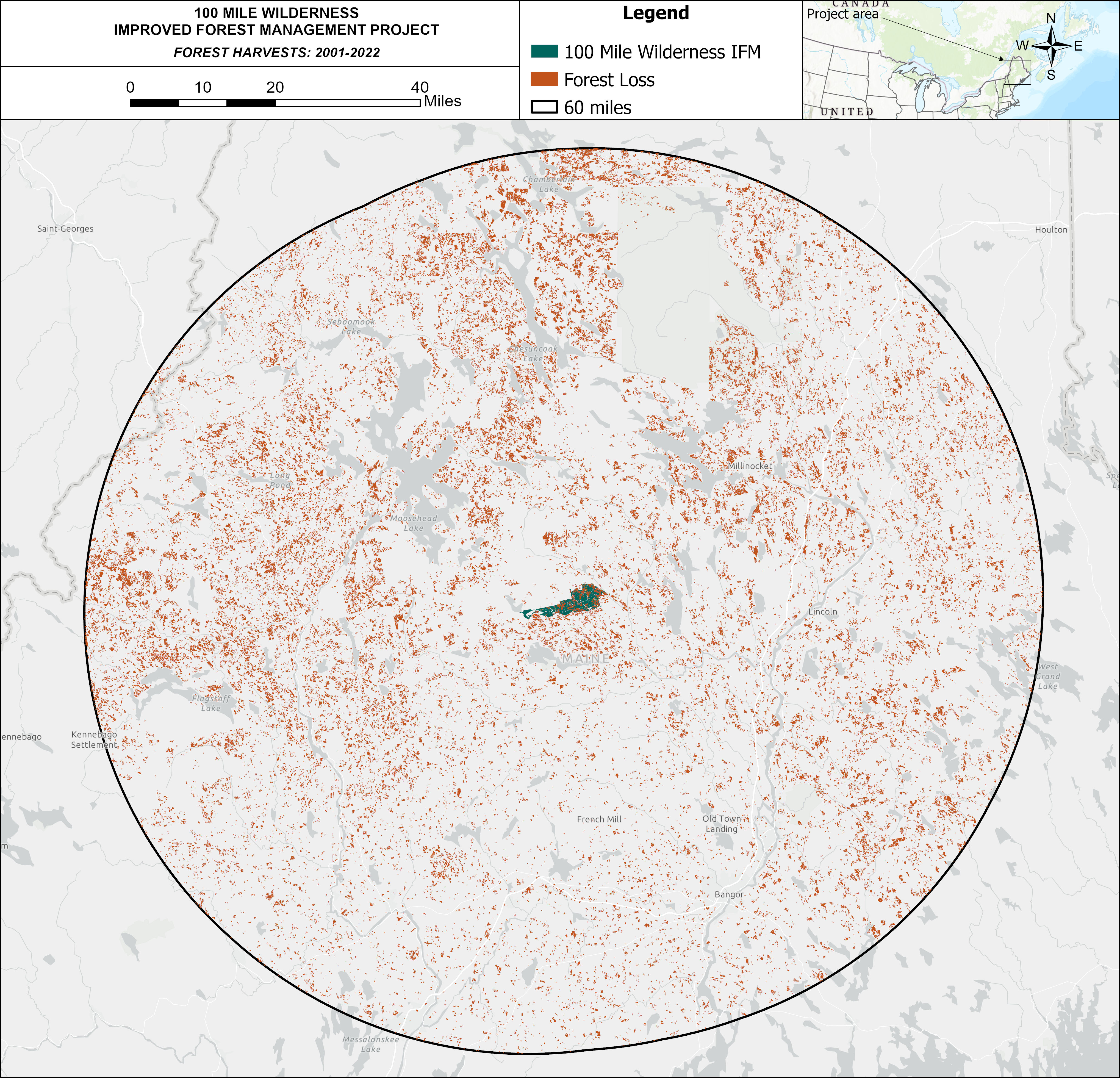
A conservative baseline scenario considers not only what a landowner could do, but what a landowner plausibly would do in the absence of the harvest limitations associated with a carbon project. In the below map, Anew demonstrates actual recent harvests in the project area’s region. This data speaks to the strength of local timber markets and common management practices on forested properties of comparable size and ownership type—an integral piece in informing the accuracy and viability of assumptions in the baseline scenario.
Harvest Comparison
All harvests/forest losses larger than 5 acres that happened between 2001 and 2022 within a 60 mile radius from the project area are depicted in orange, showing the very real pressures on forests in the area. The carbon project ensures sustainable management on the project area for 40 years, twice as long as the period depicted above.
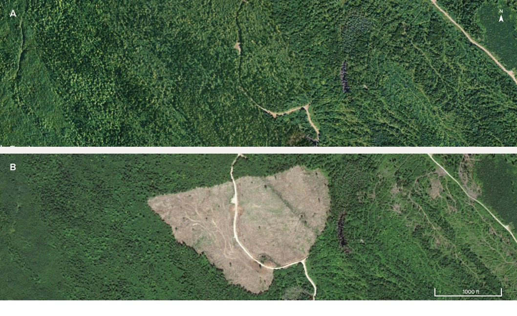
Hansen, M. C et al. "High-Resolution Global Maps of 21st-Century Forest Cover Change." Science 342 (15 November 2013 & updates): 850–53.
Regional Mill Map
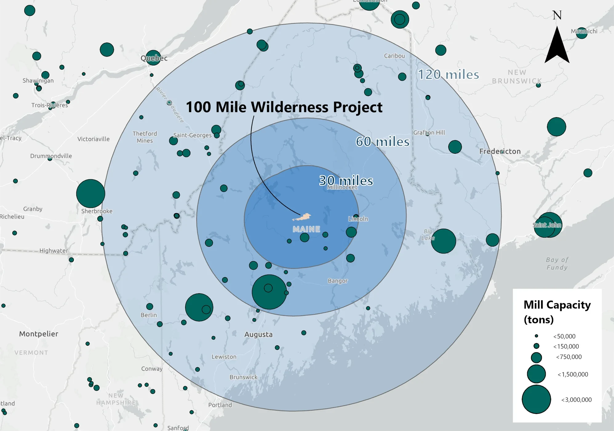
A strong understanding of local forest products infrastructure is key to building a realistic and conservative baseline scenario. To carry out harvests modeled in the baseline, a forest property must be within a feasible travel distance to active processing facilities. This map presents mills that are drivable from the project area along with their relative processing capacity, delineating a framework for a current or future landowner to move timber in the absence of the carbon project, thereby providing a critical piece of direct evidence to the credibility and additionality of the carbon credits resulting from the project’s activities.
Area Regional Mill Capacity
The calculated mill capacity is 18.96 million green tons within 120 miles of the project boundary, and the baseline harvest is 32,862 green tons per year in the first ten years of the project. This comes out to 0.17% of the 120-mile mill capacity that is represented by the 100-Mile Wilderness baseline. When AMC implements limited harvests going forward, it will have plenty of access to timber market infrastructure.
Ecological Highlight
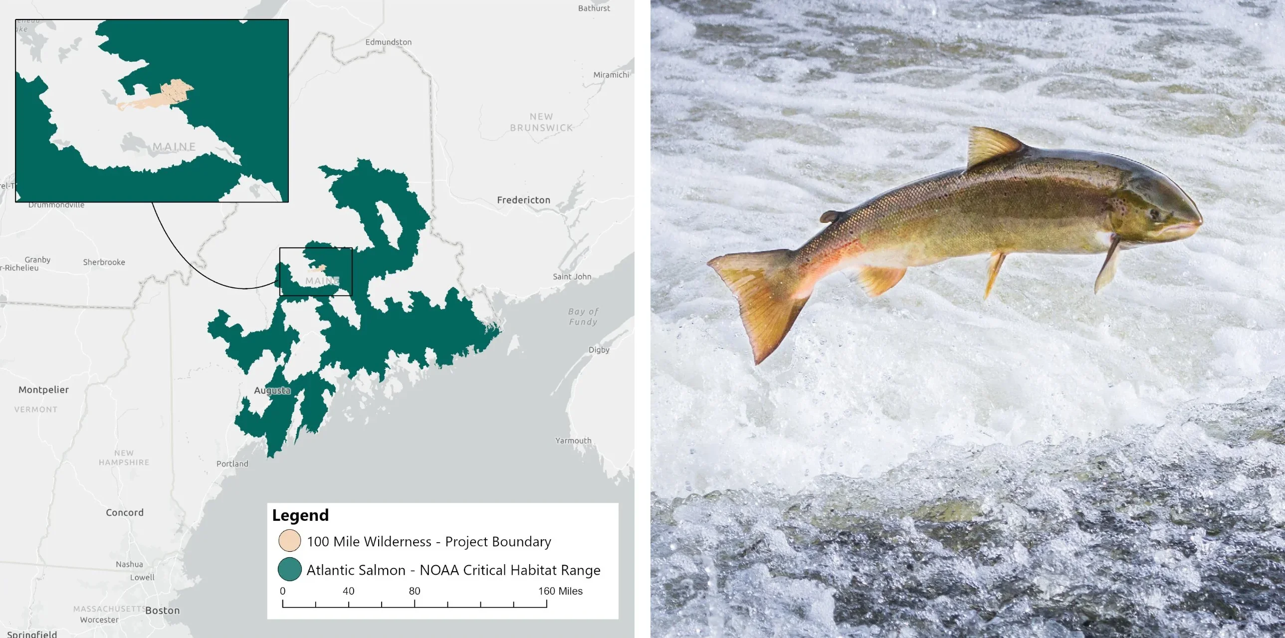
The 100-Mile Wilderness project contains several important rivers that represent habitat for the Atlantic salmon (Salmo salar), including the West Branch of the Pleasant River, Roaring Brook, and Houston Brook. The Atlantic salmon, which was once nearly extinct, is now limited only to eight rivers in the Gulf of Maine and is still at high risk. The Atlantic salmon is still listed as “endangered” under the Endangered Species Act, and habitat quality within their spawning grounds represents a significant conservation concern. The Atlantic salmon requires cold rivers with a high level of water quality for their migration efforts to be successful. By limiting harvest over a significant portion of the Atlantic salmon’s critical habitat in Maine, the 100-Mile Wilderness project protects this threatened fish from the negative effects on water quality that may result from intensive harvesting. Not only do these practices impact nearby streams, but they have also been scientifically shown to have measurable impacts at the watershed-scale.
In addition, the landowner of the 100-Mile Wilderness project has made efforts to maintain and improve Atlantic salmon habitat connectivity by evaluating road crossings over/through streams, which may pose an impediment to fish migration. In the absence of the carbon project, a more timber-focused management strategy or owner may take a less ecologically focused approach, to the detriment of salmon habitat qualities and migration abilities.
Project Impacts
Sustainable Development Goals in action
A universal blueprint for a better world—Anew is helping deliver on the United Nations global vision for social, economic, and environmental sustainability.
Quality Education
The Appalachian Mountain Club designs curriculum and leads instruction on environmental education throughout all local public schools in Piscataquis County and has dedicated staff that advocate for environmental policy at the state and national levels. Carbon revenues support organizational efforts to promote conservation ethics and environmental awareness in the region.

Clean Water and Sanitation
The property’s aquatic resources flow into the Penobscot River watershed—one of the most ecologically significant watersheds in the state of Maine as it contains critical habitat for naturally spawning, threatened Atlantic salmon. Streams on the AMC property provide habitat for eastern brook trout and some are designated as official habitat for Atlantic salmon. As part of its initiative to help restore the greater watershed, AMC has removed fish barriers on the property, increasing stream connectivity and reopening 128 miles of stream spawning habitat. This work is funded by the carbon project and delivers water quality benefits for local fish populations and downstream users in the state.

Sustainable Cities and Communities
The property’s roads were largely discontinued around twenty years ago, which diminished accessibility to parts of the property that served as a critical link to local recreational opportunities. AMC is reopening these roads so locals may return to familiar hunting and fishing areas. The funds from the 100-Mile Wilderness carbon project will help make public access to this green space viable.

Climate Action
Forest management on the property will focus on long-term carbon storage and sequestration for maximum climate change mitigation and treatments that will promote a healthier forest resilient to the effects of climate change. As part of the conservation design for the ownership, significant acreage of the property will be permanently protected in an ecological reserve free from timber harvesting, which will continually sequester carbon through annual forest growth.

Life on Land
AMC is invested in restoring its forest to an ecologically resilient state through responsible forest management, habitat restoration, and creation of ecological reserves, which are all funded through support of this project. The property is home to the Atlantic salmon and Canada lynx which are both listed as ‘Threatened’ under the Endangered Species Act among other wildlife such as moose, black bear, coyote, red fox, meadow vole, and a variety of birds and waterfowl. Reduced harvesting will increase forest cover, which will support water temperatures favorable to salmon and migration corridors favorable to lynx.
How does IFM generate both removals and conservation credits?
Conservation Credits
Conservation credits account for climate benefit coming from the protection of the project area. Emissions that would have been released if the land was instead harvested in the absence of the project are quantified. Many of the co-benefits associated with forestry projects are inherently linked to the preservation of existing forest stands.
Removal Credits
As the newly protected trees grow, carbon is pulled from the atmosphere and sequestered in the trees’ wood material through the most proven direct air capture technology on the planet, photosynthesis.