Ashland County Forestry Project
Easing harvest pressure on Wisconsin county forestland to protect carbon, water, and wildlife.
The Ashland County Forestry Project is an Improved Forest Management (IFM) initiative spanning 36,989 acres of county-owned forest in Ashland County, Wisconsin. These forests were largely obtained by the County through tax delinquency from the 1930s to the 1960s and enrolled in Wisconsin’s Forest Crop Law to be managed commercially. Harvest revenues are the County’s largest source of income outside of tax levies, and the land was harvested intensively up to the onset of the carbon project.
The project’s baseline reflects harvest levels allowed under the County’s 15-year Forest Management Plan approved by the Wisconsin DNR. Under the carbon project, the County commits to harvest levels meaningfully below those thresholds, with carbon revenue supplanting income that would otherwise come from more extensive commercial timbering. The project generates both conservation and removal credits, registered under the American Carbon Registry.
Beyond carbon impact, the project area includes over 3,000 acres of wetland habitat, fourteen streams totaling 37 miles—ten of them classified as trout streams—and habitat for the Connecticut warbler, a species of Special Concern in Wisconsin. The land is also open to the public for hunting, fishing, camping, hiking, mountain biking, and cross-country skiing, drawing visitors who support local businesses.
Additionality
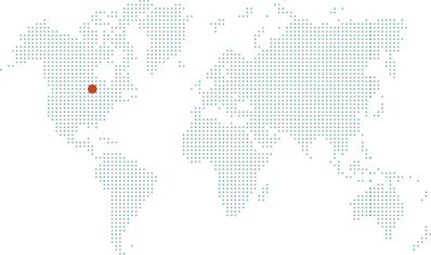
The Anew – Ashland County Forestry Project is located on 36,989 acres in Ashland County, Wisconsin. These forests were largely obtained by the County through tax delinquency from the 1930s to the 1960s and were enrolled into Wisconsin’s Forest Crop Law with the intention to be managed commercially. Harvest revenues represent the largest source of income for the County outside of tax levies, and these lands have been harvested intensively up to the onset of this carbon project.
Historically, Ashland County has relied on timber revenues to fund its municipal activities. Over the years preceding the carbon project, public resistance to tax increases has heightened attention and reliance on timber proceeds to meet County finance goals. Moreover, County funding issues are becoming more prominent as municipalities are being required to provide additional services with few, if any, opportunities to increase funds.
By committing to harvest levels meaningfully below the thresholds allowed for under the 15-year Forest Management Plan (FMP), the Ashland County Forestry Project will generate an additional revenue stream for the County, supplanting revenues that would otherwise be achieved through more extensive commercial timbering. These carbon revenues will help offset increasing funding gaps and reduce the County’s reliance on harvesting timber, which is in strong demand, as detailed by The County Forest Comprehensive Land Use Plan:
Demands for timber products in Ashland County are high. At the same time, more private land is being lost to fragmentation and parcelization. While many private landowners still desire to manage their timber resources from an economic standpoint, the change in ownership could drive up demand for County forest products.
— The County Forest Comprehensive Land Use Plan
The carbon project solidifies harvest levels meaningfully below the 15-year FMP thresholds, protecting carbon stocks from this pressure while allowing the County to allocate more resources toward the other components of its multiple-use management strategy, such as public recreation, hunting, trail use, camping, and wildlife focused goals.
Baseline Description
The baseline scenario models carbon stocking across the property under a management strategy that falls within the harvest acreage thresholds allowed for under the current 15-year Forest Management Plan currently approved by the Wisconsin DNR for the Ashland County Forest. In the absence of the carbon project commitment, the baseline harvest levels and the associated decline in carbon stocks could readily be met and would be attractive due to existing financial pressures on the County, as well as extensive mill capacity and forest product market demand throughout the region. Ashland County’s shift to a carbon-forward forest management approach allows the County to ease harvesting while still meeting its economic, social, and environmental goals for present and future generations.
Regional Harvest Activities
A conservative baseline scenario considers not only what a landowner could do, but what a landowner plausibly would do in the absence of the harvest limitations associated with a carbon project. In the following map, Anew demonstrates actual recent harvests in the project area’s region. This data speaks to the strength of local timber markets and common management practices on forested properties of comparable size and ownership type—an integral piece to inform the accuracy and viability of assumptions in the baseline scenario.
Harvest Comparison
All harvests/forest losses larger than 5 acres that happened between 2001 and 2022 within a 60 mile radius from the project area are depicted in orange, showing the very real pressures on forests in the area. The carbon project ensures sustainable management on the project area for 40 years, twice as long as the period depicted above.
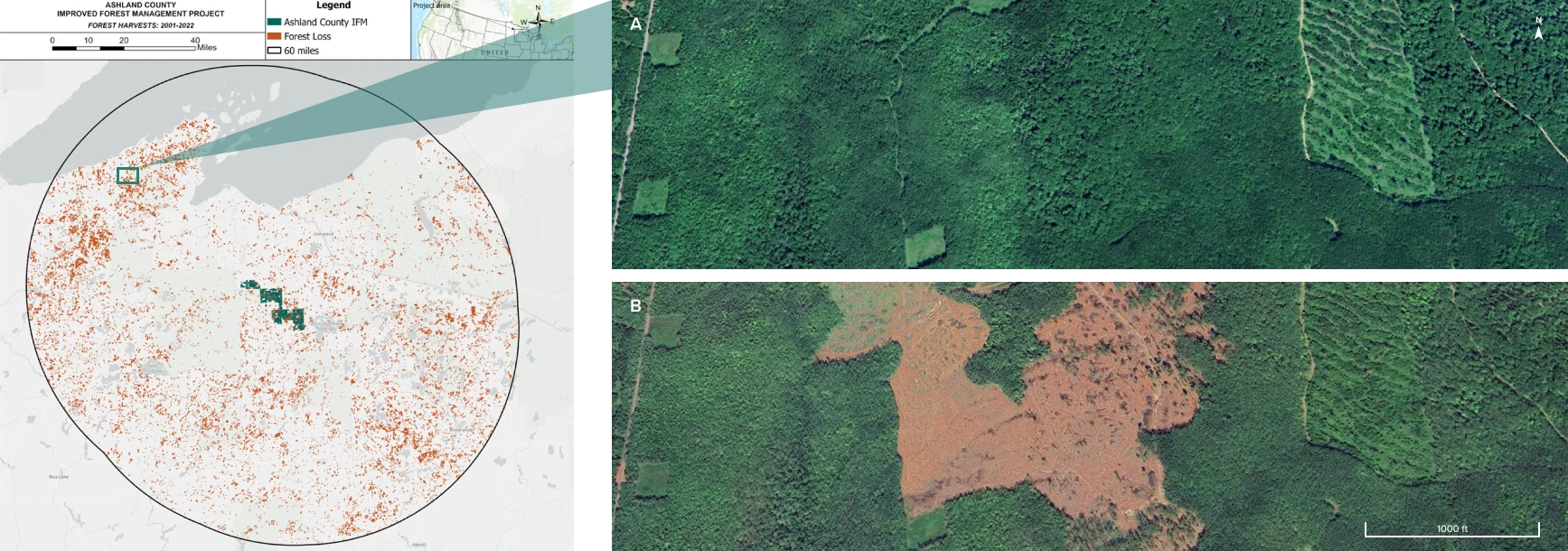
Hansen, M. C et al. "High-Resolution Global Maps of 21st-Century Forest Cover Change." Science 342 (15 November 2013 & updates): 850–53.
Regional Mill Map
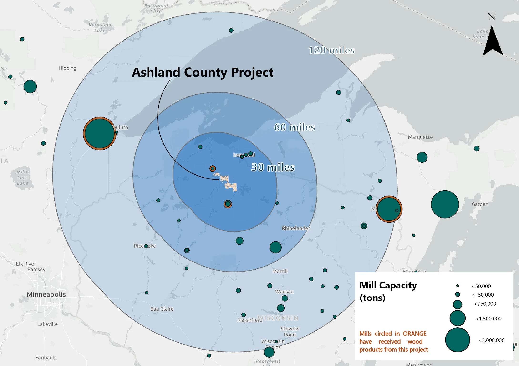
A strong understanding of local forest products infrastructure is key to building a realistic and conservative baseline scenario. To carry out harvests modeled in the baseline, a forest property must be within a feasible travel distance to active processing facilities. This map presents mills that are drivable from the project area along with their relative processing capacity, delineating a framework for a current or future landowner to move timber in the absence of the carbon project, thereby providing a critical piece of direct evidence to the credibility and additionality of the carbon credits resulting from the project’s activities.
Area Regional Mill Capacity
The calculated mill capacity is 9.60 million green tons within 120 miles of the project boundary, and the baseline harvest is 100,649 green tons per year in the first ten years of the project. This equates to 1.05% of the 120-mile mill capacity that is represented by the Ashland County baseline.
Ecological Highlight
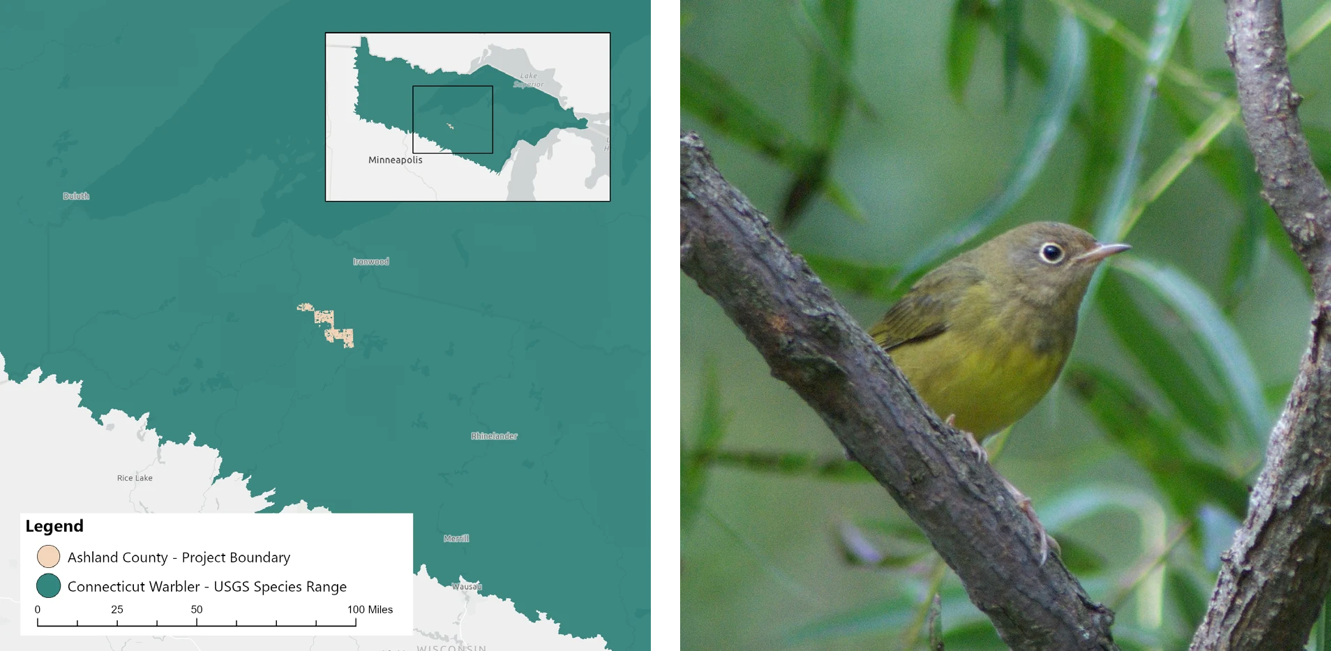
The Ashland County Project lies within the habitat range of the Connecticut warbler (Oporornis agilis), a seldom seen but important northern bird species. The Connecticut warbler prefers woody wetlands and upland jack pine stands as its habitat, and these habitat types are prominent throughout the nearly 37,000 acres of the Ashland County Project. This species nests near the ground, hidden in thick undergrowth, but also utilizes treed areas with additional overhead cover. This specific habitat preference makes it rather mysterious and difficult to locate and observe—but it remains a key part of northern ecosystems.
Unfortunately, the Connecticut warbler has decreased significantly in recent years due to habitat loss and is now a species of Special Concern in Wisconsin. This is thought to be in part because of a loss of winter habitat for the bird in the Southern Hemisphere but is also likely related to habitat fragmentation in its summer habitat. Researchers have recommended that landowners consider reducing harvest in areas of jack pines and woody wetlands and lessen fragmentation where possible. By reducing the pressure on Ashland County to maximize its profits through harvesting areas which can serve as habitat for sensitive species, the carbon project is also helping to ensure the maintenance and protection of this habitat for species like the Connecticut warbler.
Project Impacts
Sustainable Development Goals in action
A universal blueprint for a better world—Anew is helping deliver on the United Nations global vision for social, economic, and environmental sustainability.


Clean Water and Sanitation
There are over 3,000 acres of wetland habitat in the project area including sedge meadows, wet meadows, wet prairies, shallow marshes, muskeg bogs, lakes, and wetland shrubs. The Ashland County project includes fourteen streams totaling 37 miles, of which ten are classified as trout streams and three are classified as Outstanding and Exceptional Resource Waters (Tyler Forks, Bad River Slough, and Kakagon Slough). These waterways attract tourists, contribute to wild rice production in the state, and provide valuable fishery habitat. It is the mission of Ashland County to preserve, protect, and manage these water resources in a manner that recognizes natural values. As such, Ashland County utilizes protective measures beyond state BMPs in areas with highly erodible soils, streams and lakes, or steep slopes. The project activities focus on sustainable forestry and water resource stewardship, which contribute to high quality downstream drinking water, diverse habitat for aquatic species, and pristine river systems for water-based recreation.

Sustainable Cities and Communities
The Ashland County project area is available to the public for hunting, fishing, picnicking, dispersed camping, motorized travel, hiking, boating, mountain biking, snowshoeing, and cross-country skiing. By providing 2.4 million acres for public recreation, county lands draw tourists that support local businesses. As the population increases and public access to privately owned forestland decreases, the need for publicly accessible land becomes more important for communities near and far. The Ashland County project activities help ensure the long-term protection of public forest resources for recreation and outdoor tourism to benefit low-impact local economic development.

Climate Action
The project protects existing carbon stocks on county-owned forests while continuously sequestering carbon through annual forest growth. Improved forest management will increase the resilience of the forest to future climatic changes and will create verified emission reductions beyond what would happen naturally or in a business-as-usual management scenario.

Life on Land
Ashland County will manage its forests through sustainable harvest of forest products and the protection of special sites, wildlife, plants, soil, water resources, aesthetics, and recreation. A diversity of forest (northern hardwood, aspen, tamarack, cedar, balsam fir, white fir-spruce, swamp hardwood) and non-forest (bogs, open water, wetlands, rights-of-way, grasslands, shrubs, etc.) habitat types support a range of wildlife and plant species. Prior to initiating land disturbing projects, Ashland County implements strict evaluation policies to determine and prevent any potential negative impacts to local flora and fauna.
How does IFM generate both removals and conservation credits?
Conservation Credits
Conservation credits account for climate benefit coming from the protection of the project area. Emissions that would have been released if the land was instead harvested in the absence of the project are quantified. Many of the co-benefits associated with forestry projects are inherently linked to the preservation of existing forest stands.
Removal Credits
As the newly protected trees grow, carbon is pulled from the atmosphere and sequestered in the trees’ wood material through the most proven direct air capture technology on the planet, photosynthesis.